
Map my Delhi | Stories and Science Behind Some of the Capital's Monuments
Wooden school benches and tree trunks are the best proof of our need to be remembered. Whether it is a phase of life or a particularly happy chapter of romance, we mark our permanence and announce our fortitude through little signatures we hope will keep us alive through time. Because after an invincible spell, however brief, the worst fate it seems, is to settle into the dust.
A design studio in Malviya Nagar got thinking about small and superb bits of history that dot the city, resigned to being forgotten. They felt that our nameless monuments were born of brilliance and led a glorious life, and surely deserved more than just 15 seconds of Instagram fame.
Satvinder Channey of Design Route set out on a mission of telling their stories, one monument at a time, hoping that if we saw them in a different light, they’d take on a new meaning and a new life. Design Route produces beautifully designed maps of heritage edifices that integrate curated information and forgotten tales, in the hope of resurrecting heroism in the little tomb next door.
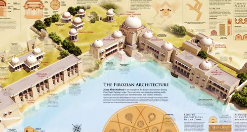
We now know that the arches in Jantar Mantar’s vertical building were not just an artifact of Mughal design, but also a possible safeguard to break the force of strong wind gusts and therefore enhance structural stability. Not to mention {PTO for the science behind it} the angle at which the structure is inclined is equal to the geographical latitude of Delhi, making it parallel to the Earth’s axis of rotation. We see by looking at the height of the enclosure wall at Hauz Khas that it was intended to define boundaries rather than defend from attack, and is an indication of stability, peace and prosperity that allowed mindspace, and perhaps financial freedom to build structures dedicated to Islamic teaching. We’re still trying to figure out the the metallurgical marvel from 1602 years ago; that which has kept the pillar at Qutb from rusting, despite being 99.7% iron.
Design Route’s maps are incredibly detailed and put together from knowledge available as easily as Wiki, or as difficult as access to thesis-level archives that require special permission to access. Even when this information is accumulated by an enthusiast or narrated by a guide, we only ever see the sum of the parts in sequence. What is spectacular about the Design Route maps is that they give a bird’s-eye view of the complex in question, so we get a complete picture of entry points and exit strategies {among other things} that kept regimes intact. And since the maps show us monuments as they originally stood, we can imagine the intention and beauty of a doorway that has given way to bad weather or poor maintenance over the last century.
Heritage maps are available for Jantar Mantar, Qutb Minar and Hauz Khas. The next map slated for release is for Red Fort – watch this space for an update.
Notes in our Little Black Book |
Meticulously detailed and beautifully designed heritage maps tell the reader about the history and science behind some of the most frequently spotted monuments in the Capital, in bite-sized chunks of information. Design Route plans to release more of these in the future, to restore lost glory to bits of Delhi history – grand, humble or otherwise.
To buy: Visit the People Tree store in Connaught Place or Intach at Lodi Road. Available online on Amazon.in, here.
For bulk orders or more information: Email channey@designroute.in or call 91 9899312947
Price: Double-sided foldable map of Jantar Mantar/Hauz Khas/Qutb Minar at INR 300 each.
